|
|
|
History
Construction of the tunnel deviation commenced in
April 1891, with a siding being built off the existing line, to a
point above where the eastern portal would be located, for delivering
construction materials. Construction of the tunnel necessitated diverting a
creek across the top of the tunnel, just a few metres from the eastern
portal, then down a cutting to join another watercourse.
To save money, a ventilation shaft was not included,
it being thought that 'the current of air passing through it should
provide sufficient ventilation.'
The opening occurred on December 20, 1892, with the
new route being hailed as a major improvement. Limitations soon became
apparent.
|
|
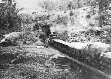
A Sydney-bound goods train crosses Knapsack Creek &
enters the tunnel. The line of the original (zig zag) railway can be seen
running across the top of the photo (this is now the highway). This
section of the original line was kept as a refuge siding. Later, it became
the start of the construction tramway leading to the Glenbrook Gorge
tunnel.
This scene is between today's native plant nursery & the RAAF base.
Photo: O.B. Bolton
|
|
The tunnel is 31˝ chains (634m) in length, passing
beneath the ridge which carried the Zig Zag line & now the
highway. It is 'S' shaped,
with reverse curves of 15 chains (302m) radius & transition curves of 30
chains (604m) radius. Gradient is a steep 1 in 33, & seepage kept the
rails wet. Wheel slippage was common. Inadequate ventilation meant that
crews endured excessive quantities of smoke, steam & coal grit;
not to mention their own perspiration. When a train stalled, the crew,
exhausted by the fumes, had to back the locomotive out of the tunnel
for another attempt.
In one instance,
".....passengers had to spend nearly an hour admiring the beauties of the interior of
Glenbrook tunnel. Whilst traversing the tunnel the train stopped, & not until divided
in two sections could progress be made. The stoppage is said to be due to the lack of
sufficient head of steam." (The Nepean Times, 12/9/1912)
A New Route
Problems with the steep, poorly ventilated tunnel, & the need to
duplicate the line, led to the construction of today's Glenbrook Gorge
route. Glenbrook Gorge opened as a single track only, with the old route
being used by downhill traffic until duplication was carried out. Continued.....
Mushrooms and Bombs
The last train ran through the tunnel in 1913. Subsequently it was
leased for mushroom growing, which continues to the present day. During
World War 2 it was used by the RAAF to store 500lb bombs, then chemical
weapons including mustard gas. The RAAF laid a concrete floor.
|
Bushwalking (Hiking)
At the eastern end, the old railway formation is
reached from Skarratt Park, in Governors Drive, Lapstone, just
beyond the highway exit.
After a few hundred metres, the line crosses Tunnel
Gully Creek
(look for the stone culvert near the left-hand gully wall) and the
vegetation gets thick. Nutrient-rich run- off from 50 years of mushroom farming
activities in the tunnel has turned the cutting into a hydroponic weed
farm, full of quicksand-like mud.
In the late 1990's, the author abandoned an attempt to
walk up the cutting, concluding that a machete & gumboots would be
needed to reach the tunnel. A visit in mid 2000 revealed that some
machete-wielding enthusiasts had recently cleared a path, & made a
start on clearing privet & lantana.
The path leaves the railway bed short of the tunnel,
ascending a narrow ridge separating the weed choked, water-logged
cutting, from a water course. The author has followed the floor of the
cutting up to the mouth of the tunnel, & found the mud to be
deeper than his gumboots. You cannot enter the tunnel. Stick to the
track, it's a lot easier!
Above the portal, a track
leads south to the old tramway route, built to carry materials to the
Glenbrook Gorge tunnel site. The tramway crosses Explorers Rd
just east of the primary school, and continues to Bluff Lookout. Just
west of the lookout, you can find remains of a funicular
railway descending into Glenbrook Gorge.
There is also a track to the end of
nearby Lucasville Rd & Hillside Cres. From Hillside
Cres, a footpath leads under the highway to the RAAF base - you can
walk down Knapsack St to the zig-zag & Knapsck
Viaduct.
Map...
More bushwalking opportunities...
|
Sewer Pipe Proposal
Sydney
Water have proposed running a sewer pipe through the tunnel and
cutting. Heritage groups have been consulted.
The proposed pipe is 375mm in diameter and
will stand 500mm high resting on its supports. Running along the side
of the tunnel & cutting, it will not interfere with future train
operations along the route, should any group ever be in a position to
make this happen. For aesthetic reasons, the pipe will dip underground
for a short distance at each portal, so as to be out of site.
Sydney Water will need to clear out the quagmire, then build an access track up the cutting, before they can start laying the
pipe. Afterwards, it should be relatively easy for local volunteers,
council or whomever to maintain the site for visitors.
Persons wishing to express their point of view may
write to Sydney Water (Attn. Kirsten Steinmaster) PO Box 557,
Liverpool 2170 or fax (02) 9828-8467.
Conservation Management Plan
A Conservation Management Plan was prepared in 1993
for the Eastern Escarpment Committee of the Blue Mountains City
Council. A copy is held at Springwood Library.
|
|
|
|
|
|
Glenbrook...
|
|
|
|

