|
Draft
Copy
|
|
|
|
By the 1890's, the Blue Mountains had become an increasingly
serious bottleneck on the colony's expanding railway network. In
addition to very steep gradients & sharp curves, there were the
zig-zags at Lapstone & Lithgow.
George
William Townshend was employed by the Works Department before taking
leave to develop his scheme for a new railway route. His team of
surveyors constructed a track up the formidable Colo River gorge,
after which he stood for parliament
in the seat of Hawkesbury to promote his scheme.
|
|
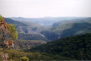
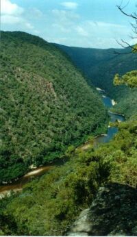
Looking west, over the Colo River wilderness, from Culoul
Range. Colo Gorge, which the railway was to follow, winds away from
the viewer in the centre.
© Anthony
Dunk
Visit Anthony's web site to see these photos, and more, full size.
Part of the 487,648 ha
Wollemi National Park. |
|
|
Townshend's route, which is marked on old
parish maps, had a lot going for it. By passing through, rather
than over, the Blue Mountains, the steep gradients were avoided.
Furthermore, most of the curves were gentle even by today's
standards, although one suspects that many railway lines were
planned with gentle
curves until the cost-cutting gang moved in. It is worth noting
that in the 1890's, Thomas Edison was speaking of electric trains
& speeds of 160km/h.
To achieve all this, Townshend made
liberal use of tunnels & bridges on the 70 odd kilometres
between meeting the Colo River & emerging at Glen Davis.
|
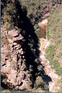
Did Townshend's
work crew appreciate the beauty of almost 70km of this kind of scenery? This is now a declared wilderness area,
within Wollemi National Park, & part of
the World Heritage listed Blue Mountains region.
© Anthony
Dunk
|
|
Roger Caffin:
The actual plans Townshend drew up included incredible stretches of tunnel
through the sandstone cliffs and immense bridges across the Colo. However, I doubt he realised just how high it would have had to be:
the Colo does rise at times... And the tunnels would probably have
been the safest part of the track, protected from the regular rock
falls.
|
|
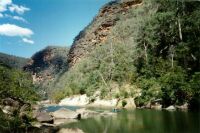
Colo River from Culoul Range. The gorge is approximately
300m (1000ft) deep here. Overnight rain can
cause a 10m rise in river level, so when you get prolonged rain.....
© Anthony
Dunk
|
|
Roger Caffin:
Some of the survey track is definitely still visible in places, although other
sections have been washed clean by floods. In places it rises quite
high above the river. Sometimes it follows a natural flood benching;
other times it follows a rock layer benching. For some of the early stages the track
carried bullocks, but further on it was reduced to single file horses.
Yes, it was nicely engineered (for the era and the resources he had). Some people would like it to be
declared a Heritage item before it is lost.
|
|
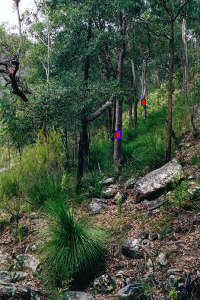
Looking along the survey track. Markers have been
superimposed on the photo, on the left side of the track.
"As you can see, a few trees have grown up and rocks have
rolled down from above, but the bench of the track is just
discernable. I actually followed the track for over 1 km without too
many probs. There's a light foot-pad along the old track where other
walkers and/or animals have gone over the years."
© Anthony
Dunk
|
Route
- To avoid crossing the Hawkesbury River
& its flood plain, the line was to start at Emu Plains, rather
than Richmond. It would meet the Mudgee Line at Rylstone.
- Between Wheeny Creek & Colo River there were to be 2 major
tunnels. It was to meet the Colo River at a point where the
south-flowing river swings back to the north in a U-turn.
- Following the west bank of Colo up to Tootie Creek, the line
diverted about 2km up Tootie Creek then tunnelled through to Colo
River.
- Between Wollangambe Ck & about 3km upstream of Wollemi
Creek, there were to be 8 major tunnels, & 4 crossings of the
Colo River. Approximately 6km of winding river was bypassed in the
vicinity of the Wollemi Creek junction through the use about 2.5km
of tunnels.
- From here to Glen Davis, there appear to have been 2 major
tunnels planned, at least 4 minor ones, & 2 closely spaced
crossings of the Capertee River.
- From Glen Davis, it is an easy run west to Rystone.
|
|
|
|
|
Photo: The railway would have come up the right-hand
side of the valley. We are looking downstream from near the Tootie
Creek junction, towards the U bend where trains from Sydney would
first meet the river.
© Anthony
Dunk
|
Problems
- High construction cost due to the
rugged terrain.
- Over 70km through country with no
traffic generating potential. The region offers no
commercially viable quantities of millable timber, minerals,
or farming land.
- The gorge is prone to slides, although
it would appear that the railway was to be in tunnels at the
worst spots.
- The river can rise dramatically after
rain - the line would have needed to be well up the side of
the gorge.
|
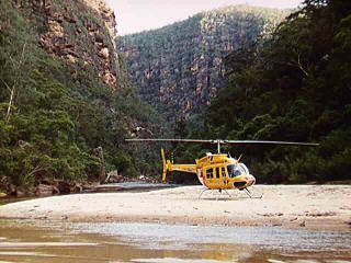
On the Colo River, near the Wollemi River
junction. This spot was to be bypassed by a tunnel.
The helicopter was retrieving the body of a lone bushwalker, who
perished after losing his way.
© Johnathan
Hobson
|
|
Up the Grose
Around 25 years earlier, a survey team from the Royal Engineers
had been sent on a similar mission up the Grose River. It turned into
a fiasco. More info...
More proposed railway routes... |
More stuff.....
Glen Davis to the
outskirts of Sydney includes a 69km sandstone gorge with 150 rapids. Overnight rain can
cause a 10m rise in river level, resulting in 69km of grade 6 rapids. Townshend's
team followed Little Wheeny Creek, before crossing "Lagoon
Ridge" & Gospers Creek to meet the Colo River at the U
bend downstream of Tootie Creek. George
William Townshend worked at the Works Department before taking
leave to work on his railway scheme. After the survey,
stood for the Seat of Hawkesbury to push his scheme.5 Traces
of the survey track can still be found on the southern/western
side of the gorge. In places it is still in good condition, a
metre wide, benched & tangled with lawyer vines.5
Sources
Material from an online discussion, involving...
1
Roger Caffin, bushwalker.
2 David
Noble, bushwalker.
3 David Bennetts, railway enthusiast.
4 Anthony
Dunk, Wollemi enthusiast &
bushwalker.
References
- 5 Colo Wilderness,
Prineas & Gold, Kaliana Press, 1978
- 6 Map of the County of
Cook, Department of Lands, 1921, revised 1973
|
|
|
|
| Back
to Routes index |
|
|

